
Globally, with over 570 million farms in operation, the significance of ‘farm boundary’ is not overstated. For individual land parcels or on a larger scale, data collection usually precedes consideration of boundaries, leaving the stakeholders to interpret information without the spatial context.
Agricultural Data lacking associated boundaries holds minimal to no value, reducing the final application’s overall effectiveness and utility. However, the question one may pose is why are farm boundaries important in the context of agricultural applications?
The answer to this lies in the advantages of farm boundary delineation one might derive in terms of:
1. Spatial context of each farm :
Farm boundaries provide a spatial reference for farm location and surrounding landscapes.
- Accurate boundaries serve as a reference for agricultural input companies to segment markets by farm sizes.
- Helps in Agriculture input companies in identifying ideal customer profiles for targeted marketing strategies.
2. Segregating farms into management units:
Each farmland typically serves as an individual management unit in agricultural applications.
- Delineated management units help in tailored planning for each farmland, including irrigation, input planning, and land usage delineation.
- It enables agricultural input companies to provide reliable advisory services to stakeholders by integrating accurate farm boundaries with precise information.
3. Optimization of resource allocation:
Utilizing delineated farm boundaries strategically provides spatial reference and precise digital land records for systemic resource allocation.
- These records eliminate the need for heavy manual surveys and reduce the costs offor maintaining data infrastructures.
- They enhance transparency with digitally accessible data, ensuring equity in land ownership and timely resource delivery.
4. Achieving decision granularity:
Integrating farm boundary data with local and regional indicators enables better-informed decisions.
- The Insights include soil type, weather conditions, yields, and commodity prices.
- Aids agricultural financial institutions in assessing individual farm performance for effective underwriting and risk evaluation.
- Empowers insurance decision-making and enhances operational efficiency through risk transparency.
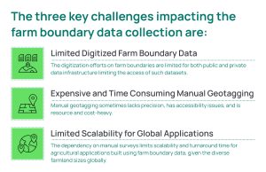
Although delineating farm boundaries might have its own set of advantages, if done manually, the range of associated challenges might outweigh the desired results.
Challenges with the Manual Farm Boundary Generation
The traditional methods of farm boundary creation rely heavily on manual surveys. These methods pose a challenge to precise farm boundary data, leading to ineffective resource allocation, land management, planning, market segmentation, and farm-level resource planning.
Redefining Farm Boundary Generation with Farm Boundary Delineation by SatSure
SatSure’s automated farm boundary delineation (FBD) model uses SatSure’s Super Resolution model to improve the openly available Sentinel-2 imagery of 10 m spatial resolution to 2.5 m spatial resolution.
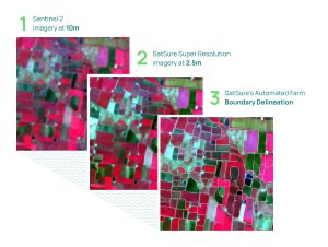
SatSure’s automated farm boundary delineation (FBD) model uses SatSure’s Super Resolution model
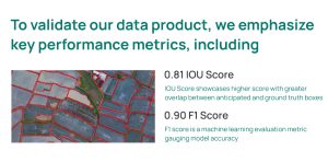
SatSure’s FBD model is tested for both accuracy and scalability. Our model has demonstrated an average of 91% model accuracy derived with an F1 score and 0.81+ IoU (Intersection over Union).
 The model has been further trained across diverse geographies with diversity in farmlands ranging from 2 Ha to 100 Ha, across countries in Latin America and South East Asia.
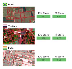
Performance metrics for regions in India, Brazil, and Thailand with an average farm size of 1 – 4 hectares
This Global-level scalability enables seamless distribution of data products across diverse geographies and agricultural practices.
Precision Agriculture enabled by deep learning models and targeted decision-making is an evolving industry segment, one that is rapidly becoming a benchmark for achieving unparalleled insights and consistent scalability. As we witness tangible results in the agricultural domain, SatSure’s farm Boundary Delineation is a working testament that timeless efficiency runs synonymous with the capability of identifying minute inconsistencies and mitigating them in time. To learn more comprehensively about the value addition of SatSure’s Automated Farm Boundary Delineation, download our detailed Brochure.


Add comment